
Villa Kamari Kritsa
Αξιοθέατα
Lato was one of the most important Doric city-states in Crete, although it must have existed before the "Coming of the Dorians". It is built on a saddle between two hills, at a site protected by possible attacks but also with a splendid view over a large area of the Mirambello Bay. It is possibly mentioned in the Linear B tablets as RA-TO. It was named after Leto (Lato is the Doric type), mother of Apollo and Artemis, although the main goddess worshipped in the city was Eileithyia, who was also depicted on the coins cut by the city. Lato was the birth-place of Nearchos, the admiral of Alexander the Great. Before the end of the 3rd century B.C., the inhabitants of Lato participated in the League of the Cretan cities and shared the same laws. Lato made many alliances with Rhodes, Teos, and king Eumenes of Pergamon. However, it was in continuous conflict with the neighbouring city of Olous, for the arrangement of the borders between them. The harbour of the city was Lato pros Kamara (modern Aghios Nikolaos), which was so flourishing by the middle of the 2nd century A.D. that the administrative centre was transferred there and Lato was subsequently abandoned.
Author
Vili Apostolakou, archaeologist
http://odysseus.culture.gr/h/3/eh351.jsp?obj_id=2444
14 polecane przez mieszkańców
Archaeological site of Lato Other
Lato was one of the most important Doric city-states in Crete, although it must have existed before the "Coming of the Dorians". It is built on a saddle between two hills, at a site protected by possible attacks but also with a splendid view over a large area of the Mirambello Bay. It is possibly mentioned in the Linear B tablets as RA-TO. It was named after Leto (Lato is the Doric type), mother of Apollo and Artemis, although the main goddess worshipped in the city was Eileithyia, who was also depicted on the coins cut by the city. Lato was the birth-place of Nearchos, the admiral of Alexander the Great. Before the end of the 3rd century B.C., the inhabitants of Lato participated in the League of the Cretan cities and shared the same laws. Lato made many alliances with Rhodes, Teos, and king Eumenes of Pergamon. However, it was in continuous conflict with the neighbouring city of Olous, for the arrangement of the borders between them. The harbour of the city was Lato pros Kamara (modern Aghios Nikolaos), which was so flourishing by the middle of the 2nd century A.D. that the administrative centre was transferred there and Lato was subsequently abandoned.
Author
Vili Apostolakou, archaeologist
http://odysseus.culture.gr/h/3/eh351.jsp?obj_id=2444
Kritsa Gorge starts near the village of Kritsa, and ends almost at the village Tapes. It’s 4km long and 1.5m wide in some places. It is easily accessible although in some points you have to climb over some big rocks but it is not too hard.
The entrance of the gorge is impressive, the mountain has been cut in two, creating the narrow passage of Havgas (havgas is a another name for gorges in East Crete). Apart from the main entrance starting next to the stone bridge of Kritsa, there's a second one starting from the village.
Try to walk through, admire the different colors of the rocks as well as the flowers during the spring which the best season to visit it.
18 polecane przez mieszkańców
Kritsa Gorge
Kritsa Gorge starts near the village of Kritsa, and ends almost at the village Tapes. It’s 4km long and 1.5m wide in some places. It is easily accessible although in some points you have to climb over some big rocks but it is not too hard.
The entrance of the gorge is impressive, the mountain has been cut in two, creating the narrow passage of Havgas (havgas is a another name for gorges in East Crete). Apart from the main entrance starting next to the stone bridge of Kritsa, there's a second one starting from the village.
Try to walk through, admire the different colors of the rocks as well as the flowers during the spring which the best season to visit it.
One of the most popular Byzantine monuments in Crete (13th- 14th A.D.) is located quite close, one kilometre, to Kritsa. It is dedicated to the Assumption of the Virgin Mary, to Saint Anthony and Saint Anna.
The central aisle ( 13th century) and its frescoes depict scenes from the Gospel. The forms are strict and imposing of ancient style.
One of the most famous monasteries of the area. Must see!!
26 polecane przez mieszkańców
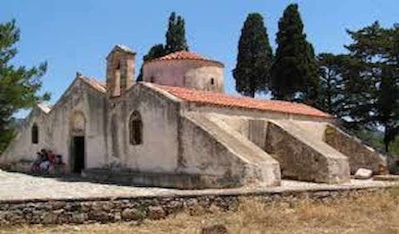
Panagias Keras Church
One of the most popular Byzantine monuments in Crete (13th- 14th A.D.) is located quite close, one kilometre, to Kritsa. It is dedicated to the Assumption of the Virgin Mary, to Saint Anthony and Saint Anna.
The central aisle ( 13th century) and its frescoes depict scenes from the Gospel. The forms are strict and imposing of ancient style.
One of the most famous monasteries of the area. Must see!!
This unique museum has a variety of endemic plants of Crete, as well as plant and animal fossils from the island. Everything has been collected with much love by naturalist Giorgos Afordakos, who is the heart of the museum.
6 polecane przez mieszkańców
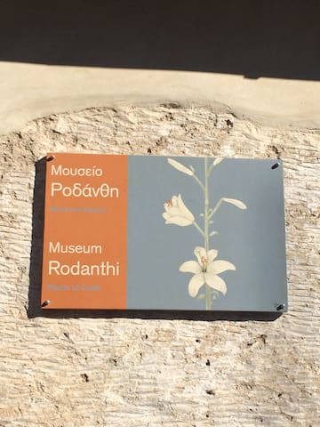
Rodanthi Museum
78 Ιωάννου ΚλώντζαThis unique museum has a variety of endemic plants of Crete, as well as plant and animal fossils from the island. Everything has been collected with much love by naturalist Giorgos Afordakos, who is the heart of the museum.
The Former Holy Monastery of Agios Ioannis Theologos, is located between the vilages Kritsa and Kroustas. The monastery was founded during the 2nd Byzantine period and there were services until the end of the 19th century.
It is is dedicated to St. John the Theologos (September 26th), and to the Transfiguration of the Savior (Master Christ- August 6th and St. Charalambos - February 10th).
The church is still adorned with frescoes dating to 1347 - 1348.
The oldest chronological element of the monastery (13th century) is the miraculous cross which today is kept in the Historical Museum of Crete.
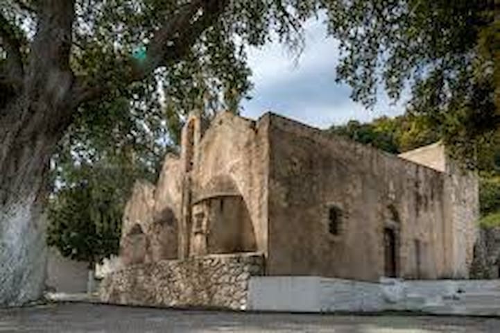
Ι.Ν. Ἁγίου Ἰωάννου Θεολόγου
The Former Holy Monastery of Agios Ioannis Theologos, is located between the vilages Kritsa and Kroustas. The monastery was founded during the 2nd Byzantine period and there were services until the end of the 19th century.
It is is dedicated to St. John the Theologos (September 26th), and to the Transfiguration of the Savior (Master Christ- August 6th and St. Charalambos - February 10th).
The church is still adorned with frescoes dating to 1347 - 1348.
The oldest chronological element of the monastery (13th century) is the miraculous cross which today is kept in the Historical Museum of Crete.
Agios Nikolaos is the capital of the Regional Unity of Lassithi and seat of the municipality of Agios Nikolaos. It is located on the northern coastline of Crete, on the west side of the Gulf of Mirabello.
The name of the city comes from the Byzantine church which located in the bay of Agios Nikolaos.
The most characteristic place of the city is the Lake Voulismeni. Many legends are associated with it due to its very deep waters, such as the fact that it has no depth. The Germans had dropped munitions on the bottom of the lake before leaving Crete in 1944, which never were found.
A walk around the lake is a very unique experience.
9 polecane przez mieszkańców
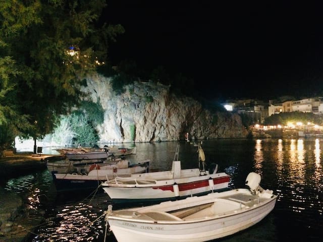
Agios Nikolaos
Agios Nikolaos is the capital of the Regional Unity of Lassithi and seat of the municipality of Agios Nikolaos. It is located on the northern coastline of Crete, on the west side of the Gulf of Mirabello.
The name of the city comes from the Byzantine church which located in the bay of Agios Nikolaos.
The most characteristic place of the city is the Lake Voulismeni. Many legends are associated with it due to its very deep waters, such as the fact that it has no depth. The Germans had dropped munitions on the bottom of the lake before leaving Crete in 1944, which never were found.
A walk around the lake is a very unique experience.
The wonderful Lassithi Plateau is a municipality and was a Province but also a picturesque plain surrounded by mountains. It is located in the prefecture of Lassithi about 70km east of Heraklion.
The well known Lassithi windmills.
The plateau is also known for its picturesque windmills. In the 1950s and 1960s, the plateau was one of the first wind farms in Europe. There were about 10-13 thousand windmills pumping groundwater, with which the inhabitants irrigated their crops.
It is located about 25km south of Malia and 70km southeast of the city of Heraklion and almost 60 km from the village Kritsa.
Oropedio Lasithiou
The wonderful Lassithi Plateau is a municipality and was a Province but also a picturesque plain surrounded by mountains. It is located in the prefecture of Lassithi about 70km east of Heraklion.
The well known Lassithi windmills.
The plateau is also known for its picturesque windmills. In the 1950s and 1960s, the plateau was one of the first wind farms in Europe. There were about 10-13 thousand windmills pumping groundwater, with which the inhabitants irrigated their crops.
It is located about 25km south of Malia and 70km southeast of the city of Heraklion and almost 60 km from the village Kritsa.
Istro- Kalo Horio is a touristic village, with amazing and famous beaches, most know the Golden beach, with blue-green water and golden sand, the quiet beach of Agios Panteleimonas and the picturesque beach of Karavostasi.
There are beautiful walks in the area, and Istro is full of archaeological interest.
For the lovers of Rock Climbing there is the Climbing field of Peza.
20 polecane przez mieszkańców

Istro
Istro- Kalo Horio is a touristic village, with amazing and famous beaches, most know the Golden beach, with blue-green water and golden sand, the quiet beach of Agios Panteleimonas and the picturesque beach of Karavostasi.
There are beautiful walks in the area, and Istro is full of archaeological interest.
For the lovers of Rock Climbing there is the Climbing field of Peza.
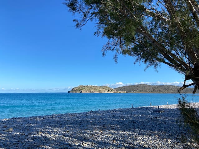
Spinalonga is a small island which closes from the north the bay of Elounda in the municipality of Agios Nikolaos in the prefecture of Lassithi, Crete. It was fortified excellently by the Venetians both in terms of construction and architecture and in terms of aesthetics of the whole landscape that still retains its beauty.
99 polecane przez mieszkańców
Nisida Spinalonga
Spinalonga is a small island which closes from the north the bay of Elounda in the municipality of Agios Nikolaos in the prefecture of Lassithi, Crete. It was fortified excellently by the Venetians both in terms of construction and architecture and in terms of aesthetics of the whole landscape that still retains its beauty.
The cypress forest of Kritsa is located about 10 km west of Kritsa, and leads to the Katharo Plateau.
The Minoan path (700m altitude) has existed since the Minoan years, is one of the most beautiful paths of Crete, wide, well-formed and with a wonderful view and one can find Minoan shells along .
Crete was covered with forests of cypresses, some centuries ago, which do not exist today.
The forest of Kritsa is the last of its kind in eastern Crete, while there are other similar forests in the White Mountains.
Kyparissódasos
The cypress forest of Kritsa is located about 10 km west of Kritsa, and leads to the Katharo Plateau.
The Minoan path (700m altitude) has existed since the Minoan years, is one of the most beautiful paths of Crete, wide, well-formed and with a wonderful view and one can find Minoan shells along .
Crete was covered with forests of cypresses, some centuries ago, which do not exist today.
The forest of Kritsa is the last of its kind in eastern Crete, while there are other similar forests in the White Mountains.
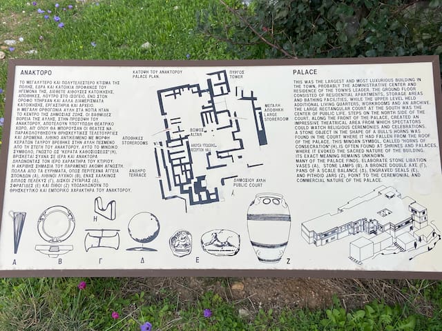
Gournia is the site of a Minoan palace complex on the island of Crete, Greece, excavated in the early 20th century by the American archaeologist, Harriet Boyd-Hawes. The original name for the site is unknown. The modern name comes from the abundant hollow vessels found all over the site.
Gournia lies in the municipality of Ierapetra in the prefecture of Lasithi.
29 polecane przez mieszkańców
Gournia Minoan Town
Gournia is the site of a Minoan palace complex on the island of Crete, Greece, excavated in the early 20th century by the American archaeologist, Harriet Boyd-Hawes. The original name for the site is unknown. The modern name comes from the abundant hollow vessels found all over the site.
Gournia lies in the municipality of Ierapetra in the prefecture of Lasithi.
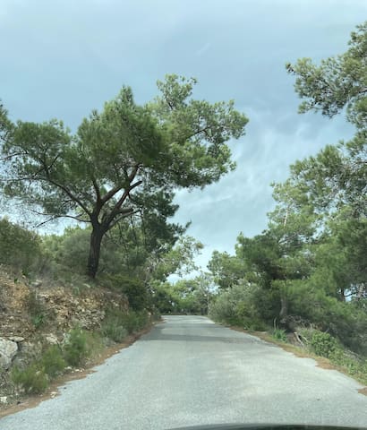
Visit the forest of Prina, enjoy a beautiful drive through Kroustas village. The route is only 16 kilometers, the forest is amazing and the from there is stunning.
forest Prina
Eparchiaki Odos Agiou Nikolaou-PrinasVisit the forest of Prina, enjoy a beautiful drive through Kroustas village. The route is only 16 kilometers, the forest is amazing and the from there is stunning.
Φαγητό
Kritsa is a village of the Municipality of Agios Nikolaos, in the regional unity of Lassithi and is built amphitheatrically at the foot of Mount Kastellos at an altitude of 330 to 365 m.
Its advantageous location allows the view of a large olive grove and of the bay of Mirabello and the Sitia mountains at the bottom of the horizon.
Its organic residential development during the last centuries gradually gave it a scorpion-like shape, which is still visible from the route to the neighboring settlement of Krousta.
Kritsa is one of the oldest and most picturesque villages in Crete,
Kritsa has an extensive historic record with evidence of occupation as early as the second millennium BC.
Walk through the village, admire the narrow alleys, let the locals treat you a raki or local delicacy.
There are also many shops which sells ceramics, handcrafts, local products. Eat at the restaurants and don't forget to ask to myzithropita a home made cheese pie.
I hope you want need it but there are two pharmacy shops in the village, just in case.
Enjoy your visit here.
42 polecane przez mieszkańców
Kritsa
Kritsa is a village of the Municipality of Agios Nikolaos, in the regional unity of Lassithi and is built amphitheatrically at the foot of Mount Kastellos at an altitude of 330 to 365 m.
Its advantageous location allows the view of a large olive grove and of the bay of Mirabello and the Sitia mountains at the bottom of the horizon.
Its organic residential development during the last centuries gradually gave it a scorpion-like shape, which is still visible from the route to the neighboring settlement of Krousta.
Kritsa is one of the oldest and most picturesque villages in Crete,
Kritsa has an extensive historic record with evidence of occupation as early as the second millennium BC.
Walk through the village, admire the narrow alleys, let the locals treat you a raki or local delicacy.
There are also many shops which sells ceramics, handcrafts, local products. Eat at the restaurants and don't forget to ask to myzithropita a home made cheese pie.
I hope you want need it but there are two pharmacy shops in the village, just in case.
Enjoy your visit here.
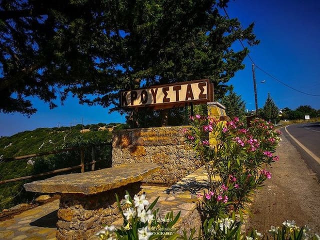
Kroustas is a village and seat of the homonymous Community located in the prefecture of Lassithi and belongs to the municipality of Agios Nikolaos (Mirabello Province). It is built at an altitude of 540 meters and near it is Kritsa, while from Agios Nikolaos it is about 13 kilometers.
14 polecane przez mieszkańców
Kroustas
Kroustas is a village and seat of the homonymous Community located in the prefecture of Lassithi and belongs to the municipality of Agios Nikolaos (Mirabello Province). It is built at an altitude of 540 meters and near it is Kritsa, while from Agios Nikolaos it is about 13 kilometers.
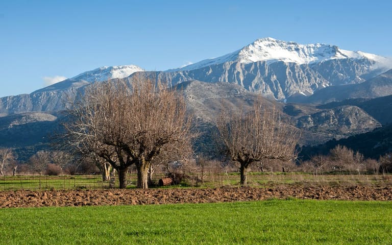
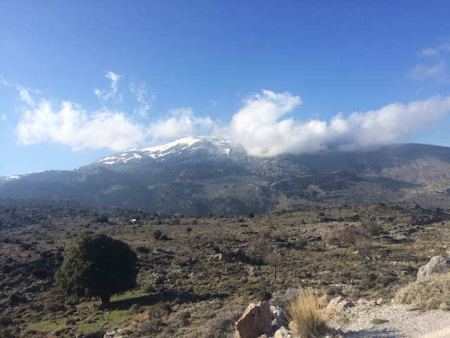
Katharo is a plateau in the Dikti mountain range in the prefecture of Lassithi, Crete. It is located at an altitude of about 1150 meters and is 16 kilometers from Kritsa, to whose community it belongs administratively, and 12 kilometers from the Lassithi plateau. It is inhabited mainly by shepherds in the summer, while there are also crops throughout the year. In Katharo there is a special status of land ownership, as the entire area of Katharo belongs exclusively to the municipal district of Kritsa, and only the permanently registered residents of the village have the right to build in Katharo.
The Plateau, 10 km long and 15 km wide, from the top of Pitouros to Lakko Kadi, consists of valleys enclosed around mountain ranges and mountains, lying to the NW. part of Kritsa and SE of the Province of Lassithi, and is 16 km away from the town of Kritsa
There are several farmhouses belonging to the village of Kritsa. You will only see a few family gardens with potatoes, apple trees and vineyards, mainly grown by the shepherds of the area. You will also see the picturesque chapel of Lord Christ, celebrating on August 6.
You will find a few taverns that cook traditional dishes and operate throughout the summer.
Finally, it is worth mentioning that the plateau is a very important point for research by paleontologists, as since the 19th century fossils of elephants and dwarf-hippos have been found, dated around 540,000 years ago. This strengthens the belief that Katharo was once a lake, around which these animals lived.
11 polecane przez mieszkańców
Katharo
Katharo is a plateau in the Dikti mountain range in the prefecture of Lassithi, Crete. It is located at an altitude of about 1150 meters and is 16 kilometers from Kritsa, to whose community it belongs administratively, and 12 kilometers from the Lassithi plateau. It is inhabited mainly by shepherds in the summer, while there are also crops throughout the year. In Katharo there is a special status of land ownership, as the entire area of Katharo belongs exclusively to the municipal district of Kritsa, and only the permanently registered residents of the village have the right to build in Katharo.
The Plateau, 10 km long and 15 km wide, from the top of Pitouros to Lakko Kadi, consists of valleys enclosed around mountain ranges and mountains, lying to the NW. part of Kritsa and SE of the Province of Lassithi, and is 16 km away from the town of Kritsa
There are several farmhouses belonging to the village of Kritsa. You will only see a few family gardens with potatoes, apple trees and vineyards, mainly grown by the shepherds of the area. You will also see the picturesque chapel of Lord Christ, celebrating on August 6.
You will find a few taverns that cook traditional dishes and operate throughout the summer.
Finally, it is worth mentioning that the plateau is a very important point for research by paleontologists, as since the 19th century fossils of elephants and dwarf-hippos have been found, dated around 540,000 years ago. This strengthens the belief that Katharo was once a lake, around which these animals lived.
Enjoy your coffee, breakfast, or have a drink in Cafe Alexandros , just opposite of the school of Kritsa, meet the locals and feel part of the family of the owners.
Cafe Alexandros
34 Epar.Od. Agiou Nikolaou-PrinasEnjoy your coffee, breakfast, or have a drink in Cafe Alexandros , just opposite of the school of Kritsa, meet the locals and feel part of the family of the owners.