
Rob's Guidebook
Towns and villages

Kirkby Stephen Parish Church
Vicarage LaNearest town with most amenities
Small farmers market once a month. Lovely village with a little chocolate factory, Orton Scar Cafe and numerous walks.

Orton Fells, Penrith CA10 3JR, Wielka Brytania
Small farmers market once a month. Lovely village with a little chocolate factory, Orton Scar Cafe and numerous walks.
Food scene
Finer dining for those who like something more than pub food. Please book in advance

Black Swan Hotel
Finer dining for those who like something more than pub food. Please book in advance

The Black Bull at Nateby
Good Pub Food
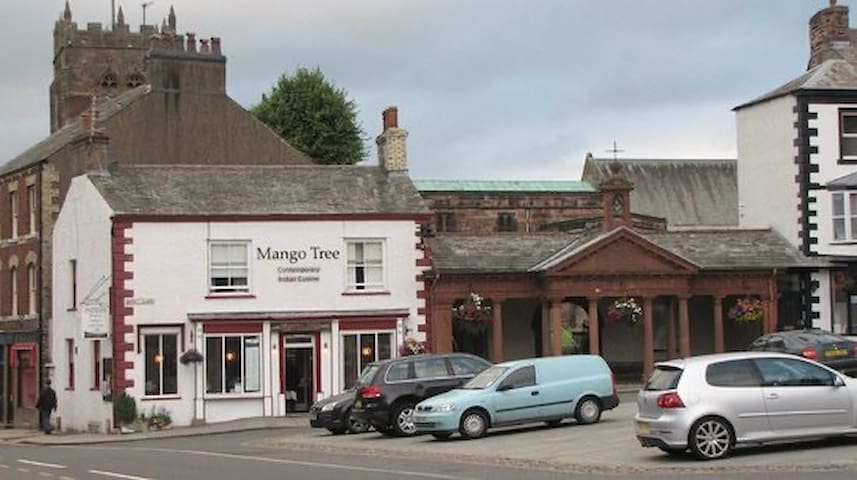
The Mango Tree
27 Market StEat in or take away, decent Indian food.
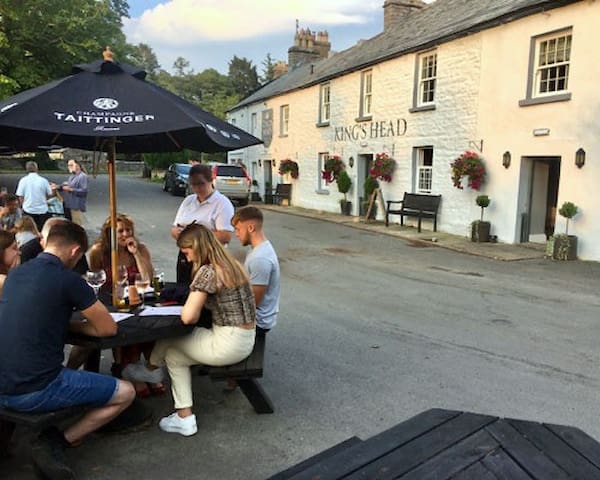
The King's Head, Ravenstonedale
Local pub
Sightseeing
Imagine a place where time had stopped and you could enjoy a steam railway experience from the past? Well, you’re thinking about Kirkby Stephen East!
Savour the atmosphere of a country station as it would have been in the 1950s. You’re sure to learn lots on your visit and have an enjoyable time.
We are home to a number of historic Victorian and other vintage locomotives, carriages and wagons which are well worth a look. You can explore our station, which was built in 1861 and served the community here for 100 years, visit the glamorous 1930s buffet car (when trains are running) and wander around our small museum.

Stainmore Railway Company
Imagine a place where time had stopped and you could enjoy a steam railway experience from the past? Well, you’re thinking about Kirkby Stephen East!
Savour the atmosphere of a country station as it would have been in the 1950s. You’re sure to learn lots on your visit and have an enjoyable time.
We are home to a number of historic Victorian and other vintage locomotives, carriages and wagons which are well worth a look. You can explore our station, which was built in 1861 and served the community here for 100 years, visit the glamorous 1930s buffet car (when trains are running) and wander around our small museum.
Walks
Frank's Bridge is a narrow pedestrian stone footbridge over the River Eden in Kirkby Stephen. It was built in the 17th century as a 'corpse lane' bridge - used to carry coffins from Hartley, Winton, and other nearby villages, for burriel at St Stephen's church. There are stones at the end of the bridge where the coffins could be rested. The bridge is thought to be named after Francis Birbeck, a local brewer (the houses around Frank’s Bridge are converted brewery buildings).[1] Frank's Bridge is Grade II listed on the National Heritage List for England. The bridge straddles the civil parishes of Kirkby Stephen and Hartley.
7 polecane przez mieszkańców

Franks Bridge
Frank's Bridge is a narrow pedestrian stone footbridge over the River Eden in Kirkby Stephen. It was built in the 17th century as a 'corpse lane' bridge - used to carry coffins from Hartley, Winton, and other nearby villages, for burriel at St Stephen's church. There are stones at the end of the bridge where the coffins could be rested. The bridge is thought to be named after Francis Birbeck, a local brewer (the houses around Frank’s Bridge are converted brewery buildings).[1] Frank's Bridge is Grade II listed on the National Heritage List for England. The bridge straddles the civil parishes of Kirkby Stephen and Hartley.
This traditional small-holding lies within the picturesque setting of the Westmorland Dales. It has been farmed in its current layout for over 400 years and is home to a series of internationally important flower-rich hay meadows.
Not only are they beautiful, they are incredibly important as only 900 hectares of these upland hay meadows survive across the counties of northern England today.
The meadows, known locally as ‘herbie’ meadows due to the abundance of flowering herbs such as wood crane’s-bill, greater burnet and lady’s mantles, are scheduled as a Site of Special Scientific Interest.

Bowber Head Farm Nature Reserve
This traditional small-holding lies within the picturesque setting of the Westmorland Dales. It has been farmed in its current layout for over 400 years and is home to a series of internationally important flower-rich hay meadows.
Not only are they beautiful, they are incredibly important as only 900 hectares of these upland hay meadows survive across the counties of northern England today.
The meadows, known locally as ‘herbie’ meadows due to the abundance of flowering herbs such as wood crane’s-bill, greater burnet and lady’s mantles, are scheduled as a Site of Special Scientific Interest.
On this route you will go along the Stainmore Railway passing the two magnificent stone viaducts at Merrygill and Podgill. There are great views along the way of the viaducts. You will pass though open fields and wooded parks and walk along the River Eden. This route has so much to offer and is a distance that suits nearly every rambler.

Podgill Viaduct
On this route you will go along the Stainmore Railway passing the two magnificent stone viaducts at Merrygill and Podgill. There are great views along the way of the viaducts. You will pass though open fields and wooded parks and walk along the River Eden. This route has so much to offer and is a distance that suits nearly every rambler.
Cautley Spout is England's highest (cascade) waterfall above ground. Steep walk with impressive views. Temperance bar at the bottom but please check opening times.
15 polecane przez mieszkańców

Cautley Spout
A683Cautley Spout is England's highest (cascade) waterfall above ground. Steep walk with impressive views. Temperance bar at the bottom but please check opening times.
Moderate walk with stunning views and the opportunity of a paddle at Sand Tarn

Wild Boar Fell, Kirkby Stephen CA17 4LL, Wielka Brytania
Moderate walk with stunning views and the opportunity of a paddle at Sand Tarn
Walk from the door and climb Green Bell one of a number of peaks in the area on the Dewey Hill List. Approx 2 hour round trip.

Green Bell, Kirkby Stephen CA17 4NW, Wielka Brytania
Walk from the door and climb Green Bell one of a number of peaks in the area on the Dewey Hill List. Approx 2 hour round trip.
Walk from the door and join the western edge of this circular walk. Relatively flat route with stunning views.

Smardale Viaduct (new)
Walk from the door and join the western edge of this circular walk. Relatively flat route with stunning views.
Weasdale Beck, Kirkby Stephen CA17, Wielka Brytania
Easy walk from the house which takes in the Beck
The highest of the Howgill Fells, The Calf sits in both the Yorkshire Dales National Park and the county of Cumbria. It’s a green, flat-topped hill, whose best ascent follows Cautley Holme Beck past the 650-foot (198 m) Cautley Spout waterfall to finish with a panorama that includes the Yorkshire Three Peaks and many miles of Lake District skyline.

The Calf, Sedbergh LA10 5LZ, Wielka Brytania
The highest of the Howgill Fells, The Calf sits in both the Yorkshire Dales National Park and the county of Cumbria. It’s a green, flat-topped hill, whose best ascent follows Cautley Holme Beck past the 650-foot (198 m) Cautley Spout waterfall to finish with a panorama that includes the Yorkshire Three Peaks and many miles of Lake District skyline.
Uldale Force is the highest and most impressive of a lovely series of waterfalls that can be found on the River Rawthey as it flows through Uldale.
Visiting Uldale Force is a rather tricky proposition. It sits in a deep ampitheatre of rocks and steep grassy slopes which, in season, are covered with primroses. To get a good look at the waterfall requires either a scramble down the banks or a similarly adventurous approach up the river. Both alternatives come with a certain amount of risk and are not for the faint hearted.
On my visit I took the river option, using the path where possible and scrambling over a few of the lower waterfalls along the way. It was an exciting and in places adrenaline filled outing. Unfortunately when I finally arrived at Uldale Force it was to find the sun shining down directly behind the waterfall which made photography rather difficult. I exited by climbing up a steep grassy rake on the northern side, not a route I’d recommend when wet!
The difficulties in reaching the waterfall make one appreciate Uldale Force all the more upon reaching it. At the foot of the waterfall is a nice pool which looked perfect for cooling the feet on a hot day.

Uldale Force, Kirkby Stephen CA17 4LL, Wielka Brytania
Uldale Force is the highest and most impressive of a lovely series of waterfalls that can be found on the River Rawthey as it flows through Uldale.
Visiting Uldale Force is a rather tricky proposition. It sits in a deep ampitheatre of rocks and steep grassy slopes which, in season, are covered with primroses. To get a good look at the waterfall requires either a scramble down the banks or a similarly adventurous approach up the river. Both alternatives come with a certain amount of risk and are not for the faint hearted.
On my visit I took the river option, using the path where possible and scrambling over a few of the lower waterfalls along the way. It was an exciting and in places adrenaline filled outing. Unfortunately when I finally arrived at Uldale Force it was to find the sun shining down directly behind the waterfall which made photography rather difficult. I exited by climbing up a steep grassy rake on the northern side, not a route I’d recommend when wet!
The difficulties in reaching the waterfall make one appreciate Uldale Force all the more upon reaching it. At the foot of the waterfall is a nice pool which looked perfect for cooling the feet on a hot day.
This circular walk explores High Cup Nick, a spectacular glacial valley and one of the major highlights in the North Pennines AONB. The whole of the valley is within an area mapped as open country under the Countryside and Rights of Way Act 2000 hence there is a general right for walkers to roam at will. The section of the Pennine Way running through the area is also a bridleway therefore legally available to cyclists and horseriders too.
This 8 mile route begins at the village of Dufton in the Eden Valley and starts by following the Pennine Way to Dod Hill and Peeping Hill. You continue your ascent to High Cup Nick where there is a waterfall and great views of the u-shaped glacial valley, the Eden Valley, Dufton Pike and Murton Pike. You'll also pass Nichol's Chair, a notable pinnacle of this rock on the northern side of the valley. It is named after a local cobbler who, for a bet, practised his craft perched on its summit.
The walk then descends through High Cup Gill where you will pass boulder fields on your way to High Cup Gill Beck. You continue along the beck through Middletongue Crag to Harbour Flatt where you join a country lane, taking you back to Dufton.
This is a special place with some spectacular geological wonders to enjoy. It is quite a steep and challenging climb but the footpaths are generally good for most of the walk.
An alternative route starts from Cow Green Reservoir, approaching High Cup from the east and following the Pennine Way to the summit.
If you would like to continue your walk you could head to the nearby Cow Green Reservoir and visit the wonderful Cauldron Snout waterfall. The circular High Force Waterfall Walk is another major highlight of the area. You could also head to Cross Fell for more wonderful views of the area.
17 polecane przez mieszkańców

High Cup Nick
Pennine WayThis circular walk explores High Cup Nick, a spectacular glacial valley and one of the major highlights in the North Pennines AONB. The whole of the valley is within an area mapped as open country under the Countryside and Rights of Way Act 2000 hence there is a general right for walkers to roam at will. The section of the Pennine Way running through the area is also a bridleway therefore legally available to cyclists and horseriders too.
This 8 mile route begins at the village of Dufton in the Eden Valley and starts by following the Pennine Way to Dod Hill and Peeping Hill. You continue your ascent to High Cup Nick where there is a waterfall and great views of the u-shaped glacial valley, the Eden Valley, Dufton Pike and Murton Pike. You'll also pass Nichol's Chair, a notable pinnacle of this rock on the northern side of the valley. It is named after a local cobbler who, for a bet, practised his craft perched on its summit.
The walk then descends through High Cup Gill where you will pass boulder fields on your way to High Cup Gill Beck. You continue along the beck through Middletongue Crag to Harbour Flatt where you join a country lane, taking you back to Dufton.
This is a special place with some spectacular geological wonders to enjoy. It is quite a steep and challenging climb but the footpaths are generally good for most of the walk.
An alternative route starts from Cow Green Reservoir, approaching High Cup from the east and following the Pennine Way to the summit.
If you would like to continue your walk you could head to the nearby Cow Green Reservoir and visit the wonderful Cauldron Snout waterfall. The circular High Force Waterfall Walk is another major highlight of the area. You could also head to Cross Fell for more wonderful views of the area.
Borrowdale is a valley in the English Lake District. It is located in the county of Westmorland, and is sometimes referred to as Westmorland Borrowdale in order to distinguish it from a more famous Borrowdale located in Cumberland.
The valley straddles the eastern border of the Lake District National Park, and is part of Westmorland and Furness.
The valley carries Borrow Beck for 11 kilometres (6.8 mi), from Borrowdale Hole, through Borrowdale Moss to End of Borrowdale, crossing the A6 road at High Borrow Bridge and reaching the River Lune at Low Borrow Bridge, site of a Roman fort, and where the original bridge has been supplemented by a new bridge for the A685 road, and by twin viaducts for the M6 motorway, and for the West Coast Main Line
The upper segment, above High Borrow Bridge, is very remote; the lower segment carries a bridleway along its length, and has easy parking at the eastern end just off the A685, but remains quiet even in the high season.

Borrowdale, Westmorland, Penrith CA10 3XY, Wielka Brytania
Borrowdale is a valley in the English Lake District. It is located in the county of Westmorland, and is sometimes referred to as Westmorland Borrowdale in order to distinguish it from a more famous Borrowdale located in Cumberland.
The valley straddles the eastern border of the Lake District National Park, and is part of Westmorland and Furness.
The valley carries Borrow Beck for 11 kilometres (6.8 mi), from Borrowdale Hole, through Borrowdale Moss to End of Borrowdale, crossing the A6 road at High Borrow Bridge and reaching the River Lune at Low Borrow Bridge, site of a Roman fort, and where the original bridge has been supplemented by a new bridge for the A685 road, and by twin viaducts for the M6 motorway, and for the West Coast Main Line
The upper segment, above High Borrow Bridge, is very remote; the lower segment carries a bridleway along its length, and has easy parking at the eastern end just off the A685, but remains quiet even in the high season.
Moderate climb up to Nine Standards. Spectacular views.
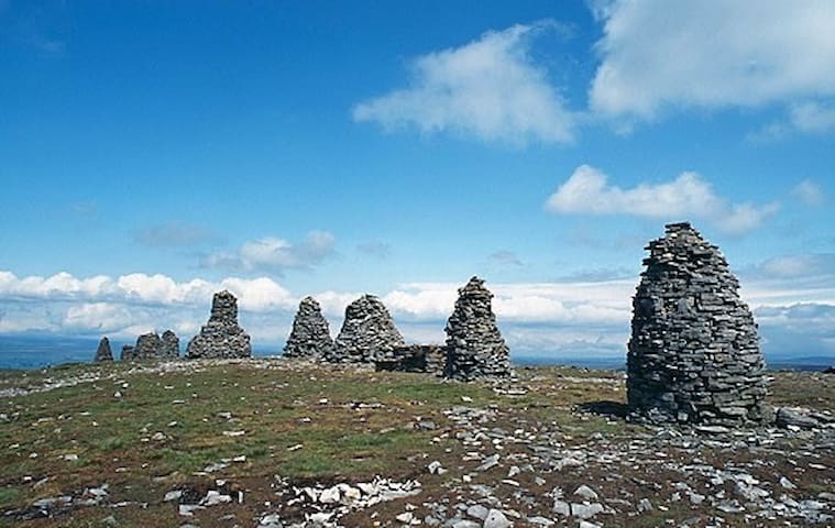
Nine Standards Rigg, Kirkby Stephen CA17 4JF, Wielka Brytania
Moderate climb up to Nine Standards. Spectacular views.