
Westerly and surrounding area
Parks & Nature
Forest for hiking and camping and Wachaug Pond. The Vin Gormley Trail makes a circle around Wachaug Pond; about 18km.
21 polecane przez mieszkańców
Stanowy Park Burlingame
1 Burlingame State Park RdForest for hiking and camping and Wachaug Pond. The Vin Gormley Trail makes a circle around Wachaug Pond; about 18km.
Park with amenities such as tennis courts, playing fields, bike trails located at the water's edge on an old airfield.
36 polecane przez mieszkańców
Ninigret Park
5 Park LnPark with amenities such as tennis courts, playing fields, bike trails located at the water's edge on an old airfield.
Misquamicut State Beach
Large State Beach parking with amenities.
East Beach
East Beach RoadWilcox Park
44 Broad StEast Beach
East Beach RoadNarragansett Beach
39 Boston Neck RoadMatunuck
Matunuck Beach RdA walk down the sand trail - Ninigret Avenue will bring you to the remains of USLSS # 57 located close to the Charlestown Breachway.
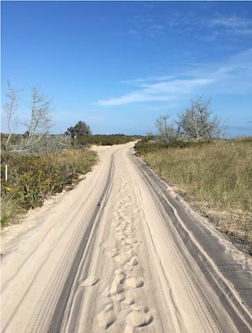
Sand Trail
Sand TrailA walk down the sand trail - Ninigret Avenue will bring you to the remains of USLSS # 57 located close to the Charlestown Breachway.
Beautiful location at the site of the nation's 3rd oldest light house. Rocks at the shore line to explore and a large park.
34 polecane przez mieszkańców
Beavertail Lighthouse Museum
Beavertail RoadBeautiful location at the site of the nation's 3rd oldest light house. Rocks at the shore line to explore and a large park.
Fort Wetherill State Park
3 Fort Wetherill RdBeautiful here!
Beautiful woods very close by. Mountain bikes are welcome here. Many mountain bike trails.
Woody Hill Management Area
Beautiful woods very close by. Mountain bikes are welcome here. Many mountain bike trails.
Some of the properties that Westerly Land Trust owns are open to the public and have nice hiking trails. An interesting one down the street from us is the "Dr. John Champlin Glacier Park". Here there are signs explaining how the glacier formed the land we live on. From "Charlie's Overlook" you can look over Winnapaug Pond to Misquamicut Beach out to the Atlantic Ocean and sometimes Block Island and Long Island are in sight. Go to westerlylandtrust.org for detailed information.
Westerly Land Trust
Some of the properties that Westerly Land Trust owns are open to the public and have nice hiking trails. An interesting one down the street from us is the "Dr. John Champlin Glacier Park". Here there are signs explaining how the glacier formed the land we live on. From "Charlie's Overlook" you can look over Winnapaug Pond to Misquamicut Beach out to the Atlantic Ocean and sometimes Block Island and Long Island are in sight. Go to westerlylandtrust.org for detailed information.
Some of the properties that Westerly Land Trust owns are open to the public and have nice hiking trails. An interesting one down the street from us is the "Dr. John Champlin Glacier Park". Here there are signs explaining how the glacier formed the land we live on. From "Charlie's Overlook" you can look over Winnapaug Pond to Misquamicut Beach out to the Atlantic Ocean and sometimes Block Island and Long Island are in sight. Go to westerlylandtrust.org for detailed information.
Dr. John Champlin Glacier Park
5 Kettle ClSome of the properties that Westerly Land Trust owns are open to the public and have nice hiking trails. An interesting one down the street from us is the "Dr. John Champlin Glacier Park". Here there are signs explaining how the glacier formed the land we live on. From "Charlie's Overlook" you can look over Winnapaug Pond to Misquamicut Beach out to the Atlantic Ocean and sometimes Block Island and Long Island are in sight. Go to westerlylandtrust.org for detailed information.
Stonington Lighthouse Museum
7 Water StBlock Island. A nice day excursion. Take the ferry from Galilee.
33 polecane przez mieszkańców
New Shoreham
Block Island. A nice day excursion. Take the ferry from Galilee.
Fort Mansfield
Take a walk out to the old Fort remains.
White Rock
Skate park in Westerly
Quonochontaug Pond is our nearby coastal lagoon.
Quonochontaug means black fish.
It is the deepest and most saline of the salt ponds. It is now connected directly to the sea by a breachway that was stabilized with rock jetties by the US Army Corps of Engineers in the 1950s.
The town boundary between Westerly and Charlestown cuts through the middle of the pond.
Water quality in past years has been very good because the pond is relatively deep, well flushed by the tides, and development has been limited. Quonnie is the least intensely developed of any of the ponds. Most of the development is residential and much of it is occupied only seasonally.
Like all of the ponds, Quonnie is an important nursery for winter flounder, young striped bass, blue fish, and tautog. Bay scallops fluctuate in abundance from year to year, but in a good year, they are often found in this salt pond.
The shoreline is part of the Atlantic Flyway, a major migratory bird resting area.
“The salt ponds have probably been in some kind of existence, they wouldn’t have looked exactly like today but probably would have been in about the same spots about 4 - 5,000 years ago,” said Bryan Oakley, associate professor of environmental geosciences at Eastern Connecticut State University. “That coincides with when global sea level was kind of slowing down when the last of the Laurentide, the big ice sheet, started to melt. They’re not geologically super old, but certainly, they’ve been around for a number of thousands of years. What was on the shore face or the area offshore before that, we don’t have a good handle, because they would have gotten chewed up as the shoreline migrated across to where it is today.”
The sea level was more than 3 feet lower during that early period, so sections of the ponds that are now shallow would probably have been completely dry.
“Areas in the back that are shallowed out would not have been inundated yet,” Oakley noted. “They wouldn’t have had water on them … The exact extent of inundation kind of depends on the elevation of the land underneath the lagoon.”
Each of the salt ponds has its own geological characteristics, determined by the retreat of the glacier, which began about 11,600 years ago.
The salt ponds have been and continue to be a valuable resource for members of the Narragansett Indian Tribe. Lorén Spears, executive director of the Tomaquag Museum, described traditional practices that extended far beyond fishing and shellfishing.
“Everything that was edible was eaten and everything that was useful was used in any way that it could be made into something else,” she said. “Just to use an example, a shell like the quahog shell, it’s not just the food, but the shell can be turned into a ladle. It can be flipped over the other way and with a long stick, be a hoe for your garden. It can be broken apart and cut and shaped into beads, wampum beads or white beads or the purple beads that we know today as wampum. Everything has multiple uses, so our ancestors and even our people still today often think, is it edible? Is it medicinal? Is it useful? Is it spiritual? And in many cases, it’s all of the above.”
The salt ponds are relatively shallow, allowing sunlight to reach the bottom, which encourages the growth of eelgrass. With their sheltered, calmer waters, the ponds are also important nurseries for fish and shellfish, and give them access to the ocean when they are more mature. The ponds also provide important food sources for birds, migrating monarch butterflies and horseshoe crabs, and serve as buffers during storms.
Art Ganz, a retired marine biologist who has lived on the shore of Quononchontaug Pond since 1970, is the director of the Salt Ponds Coalition. Incorporated in 1984, the coalition monitors water quality, conducts public outreach programs and promotes the protection and conservation of the salt ponds at the state's General Assembly.
Ganz agreed that development is a significant contributor to the decline of the ponds' health. Small summer cottages have given way to large year-round homes that are crammed onto small shoreline lots. More efficient septic systems, which remove nitrogen, have encouraged more building along the shore.
“Years ago, people had an outhouse, a seasonal house, a cesspool, they probably didn’t have washers and dryers in those cottages,” he said. “Today, they’re big, big houses and they house lots of people and unfortunately, the technology that was developed for these denitrification systems was essentially intended to improve the efficiency of areas, say, replace a cesspool with a denitrification system. But the back side of it is, because of this technology, a lot of these properties that we would consider unbuildable, with high groundwater and everything else, are now allowed to be built on. So as far as I’m concerned, this kind of backfired.”
In addition to effluent from septic systems, nutrients from animal and bird waste and lawn fertilizers enter the ponds. Nutrient overloads are the cause of eutrophication, a condition that depletes the oxygen in the water. Coliform and Enterococcus bacterial contamination, which was a problem in 2018, is also a growing concern.
Ganz said it is a challenge to make summer residents aware of environmental conditions until they are personally affected by them.
“I get very, very frustrated, particularly where I live,” he said. “There’s so many summer people that come in and everything is rosy from Memorial Day to Labor Day, but they really don’t care too much about what goes on in the off season and the changes that we are seeing, the changes in our beaches, the effect of the king tides and the ever-so-gradual sea level rise that people don’t pay attention to. These are very real things that need to be looked at on a year-round basis … We saw this when we had the bacterial problem in some of the ponds. People were some upset.”
For many Rhode Islanders, including members of the Narragansett Tribe, dense development has also created an access problem.
“We’re eastern woodland coastal people but we don’t have direct access in the sense of lands that are ours, that are on the salt ponds,” Spears said. “Every year, there’s always some kind of new blockade to keep people out of salt pond areas in various places in South County.”
Cassius Spears, director of the Narragansett Food Sovereignty Initiative, described once-productive ecosystems that were dramatically altered when the ponds became thickly settled.
“You can go down to the pond any time of the year and you’ll see myself or a family member … just enjoying the therapeutic part of reminiscing about how this pond must have looked during the time of our ancestors,” Spears said. “So when you want to look at changes around the pond, and I tell this even to my grandchildren, I point around the pond and I say, ‘Look, see all these houses over here? How many Indians do you think live in some of these houses here? I think you’ll find it’s most likely not even one.'"
Spears said he likes going to Ninigret Pond because it is relatively accessible and the least degraded. “I feel that it probably has the least amount of abuse than all the ponds in the area,” he said. “To be able to go and see a nice bed of eelgrass is really important, especially when you see how devastated the other ponds in the area are.”
Recent dredging at Ninigret and Quonochontaug ponds has raised the hope that water quality will improve with increased tidal flushing.
“We have dredged, including just this last year,” Lee said. “Initially, the sand all went back on the beach where it came from … to re-nourish the beach system. Last year, they went onto salt marshes because there’s concern that we’re going to lose our salt marshes because they’re not keeping up with sea level rise. That’s really an experiment to see if that’s doable.”
As conditions around and in the salt ponds change, there will be no choice but to adapt. The only constant with the salt ponds, Oakley said, is continuous change. Storms impact the barrier beaches, which in turn have an impact on the salt ponds behind them.
“The bottom line is, no matter what, it’s not going to get better because they’re migrating under the influence of storms and in the background of all that is sea level rise,” he said. “What sea level rise starts to do is give more significant impacts to smaller but more frequent storm events, so we’re not waiting on infrequent storms to have a big impact. You start to have a more significant impact from smaller event … The barriers might migrate faster and then, sometime down the road geologically, we’ll be talking about what’s happening with the size of the lagoon or the changes to the lagoon, because of the barriers moving back. It’s always been a dynamic system and the geological reality is they’re extremely dynamic systems and they’re formed and modified by those important processes.”
Many text parts taken from Salt Pond Watchers Summary Data Report 1985 – 1987, Coastal Resources Center, University of Rhode Island Technical Report No. 10, October 1990, by P. Kullberg, V. Lee, and M. Platt, and a Dec 27, 2019 article from The Westerly Sun by Cynthia Drummond titled "Charlestowns salt ponds are ecosystems in transition".
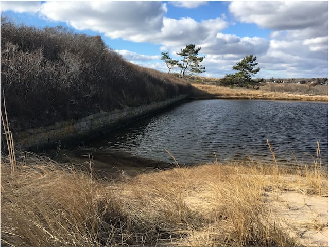
Quonochontaug Pond, Rhode Island, Stany Zjednoczone
Quonochontaug Pond is our nearby coastal lagoon.
Quonochontaug means black fish.
It is the deepest and most saline of the salt ponds. It is now connected directly to the sea by a breachway that was stabilized with rock jetties by the US Army Corps of Engineers in the 1950s.
The town boundary between Westerly and Charlestown cuts through the middle of the pond.
Water quality in past years has been very good because the pond is relatively deep, well flushed by the tides, and development has been limited. Quonnie is the least intensely developed of any of the ponds. Most of the development is residential and much of it is occupied only seasonally.
Like all of the ponds, Quonnie is an important nursery for winter flounder, young striped bass, blue fish, and tautog. Bay scallops fluctuate in abundance from year to year, but in a good year, they are often found in this salt pond.
The shoreline is part of the Atlantic Flyway, a major migratory bird resting area.
“The salt ponds have probably been in some kind of existence, they wouldn’t have looked exactly like today but probably would have been in about the same spots about 4 - 5,000 years ago,” said Bryan Oakley, associate professor of environmental geosciences at Eastern Connecticut State University. “That coincides with when global sea level was kind of slowing down when the last of the Laurentide, the big ice sheet, started to melt. They’re not geologically super old, but certainly, they’ve been around for a number of thousands of years. What was on the shore face or the area offshore before that, we don’t have a good handle, because they would have gotten chewed up as the shoreline migrated across to where it is today.”
The sea level was more than 3 feet lower during that early period, so sections of the ponds that are now shallow would probably have been completely dry.
“Areas in the back that are shallowed out would not have been inundated yet,” Oakley noted. “They wouldn’t have had water on them … The exact extent of inundation kind of depends on the elevation of the land underneath the lagoon.”
Each of the salt ponds has its own geological characteristics, determined by the retreat of the glacier, which began about 11,600 years ago.
The salt ponds have been and continue to be a valuable resource for members of the Narragansett Indian Tribe. Lorén Spears, executive director of the Tomaquag Museum, described traditional practices that extended far beyond fishing and shellfishing.
“Everything that was edible was eaten and everything that was useful was used in any way that it could be made into something else,” she said. “Just to use an example, a shell like the quahog shell, it’s not just the food, but the shell can be turned into a ladle. It can be flipped over the other way and with a long stick, be a hoe for your garden. It can be broken apart and cut and shaped into beads, wampum beads or white beads or the purple beads that we know today as wampum. Everything has multiple uses, so our ancestors and even our people still today often think, is it edible? Is it medicinal? Is it useful? Is it spiritual? And in many cases, it’s all of the above.”
The salt ponds are relatively shallow, allowing sunlight to reach the bottom, which encourages the growth of eelgrass. With their sheltered, calmer waters, the ponds are also important nurseries for fish and shellfish, and give them access to the ocean when they are more mature. The ponds also provide important food sources for birds, migrating monarch butterflies and horseshoe crabs, and serve as buffers during storms.
Art Ganz, a retired marine biologist who has lived on the shore of Quononchontaug Pond since 1970, is the director of the Salt Ponds Coalition. Incorporated in 1984, the coalition monitors water quality, conducts public outreach programs and promotes the protection and conservation of the salt ponds at the state's General Assembly.
Ganz agreed that development is a significant contributor to the decline of the ponds' health. Small summer cottages have given way to large year-round homes that are crammed onto small shoreline lots. More efficient septic systems, which remove nitrogen, have encouraged more building along the shore.
“Years ago, people had an outhouse, a seasonal house, a cesspool, they probably didn’t have washers and dryers in those cottages,” he said. “Today, they’re big, big houses and they house lots of people and unfortunately, the technology that was developed for these denitrification systems was essentially intended to improve the efficiency of areas, say, replace a cesspool with a denitrification system. But the back side of it is, because of this technology, a lot of these properties that we would consider unbuildable, with high groundwater and everything else, are now allowed to be built on. So as far as I’m concerned, this kind of backfired.”
In addition to effluent from septic systems, nutrients from animal and bird waste and lawn fertilizers enter the ponds. Nutrient overloads are the cause of eutrophication, a condition that depletes the oxygen in the water. Coliform and Enterococcus bacterial contamination, which was a problem in 2018, is also a growing concern.
Ganz said it is a challenge to make summer residents aware of environmental conditions until they are personally affected by them.
“I get very, very frustrated, particularly where I live,” he said. “There’s so many summer people that come in and everything is rosy from Memorial Day to Labor Day, but they really don’t care too much about what goes on in the off season and the changes that we are seeing, the changes in our beaches, the effect of the king tides and the ever-so-gradual sea level rise that people don’t pay attention to. These are very real things that need to be looked at on a year-round basis … We saw this when we had the bacterial problem in some of the ponds. People were some upset.”
For many Rhode Islanders, including members of the Narragansett Tribe, dense development has also created an access problem.
“We’re eastern woodland coastal people but we don’t have direct access in the sense of lands that are ours, that are on the salt ponds,” Spears said. “Every year, there’s always some kind of new blockade to keep people out of salt pond areas in various places in South County.”
Cassius Spears, director of the Narragansett Food Sovereignty Initiative, described once-productive ecosystems that were dramatically altered when the ponds became thickly settled.
“You can go down to the pond any time of the year and you’ll see myself or a family member … just enjoying the therapeutic part of reminiscing about how this pond must have looked during the time of our ancestors,” Spears said. “So when you want to look at changes around the pond, and I tell this even to my grandchildren, I point around the pond and I say, ‘Look, see all these houses over here? How many Indians do you think live in some of these houses here? I think you’ll find it’s most likely not even one.'"
Spears said he likes going to Ninigret Pond because it is relatively accessible and the least degraded. “I feel that it probably has the least amount of abuse than all the ponds in the area,” he said. “To be able to go and see a nice bed of eelgrass is really important, especially when you see how devastated the other ponds in the area are.”
Recent dredging at Ninigret and Quonochontaug ponds has raised the hope that water quality will improve with increased tidal flushing.
“We have dredged, including just this last year,” Lee said. “Initially, the sand all went back on the beach where it came from … to re-nourish the beach system. Last year, they went onto salt marshes because there’s concern that we’re going to lose our salt marshes because they’re not keeping up with sea level rise. That’s really an experiment to see if that’s doable.”
As conditions around and in the salt ponds change, there will be no choice but to adapt. The only constant with the salt ponds, Oakley said, is continuous change. Storms impact the barrier beaches, which in turn have an impact on the salt ponds behind them.
“The bottom line is, no matter what, it’s not going to get better because they’re migrating under the influence of storms and in the background of all that is sea level rise,” he said. “What sea level rise starts to do is give more significant impacts to smaller but more frequent storm events, so we’re not waiting on infrequent storms to have a big impact. You start to have a more significant impact from smaller event … The barriers might migrate faster and then, sometime down the road geologically, we’ll be talking about what’s happening with the size of the lagoon or the changes to the lagoon, because of the barriers moving back. It’s always been a dynamic system and the geological reality is they’re extremely dynamic systems and they’re formed and modified by those important processes.”
Many text parts taken from Salt Pond Watchers Summary Data Report 1985 – 1987, Coastal Resources Center, University of Rhode Island Technical Report No. 10, October 1990, by P. Kullberg, V. Lee, and M. Platt, and a Dec 27, 2019 article from The Westerly Sun by Cynthia Drummond titled "Charlestowns salt ponds are ecosystems in transition".
Food Scene
Many good restaurants to choose from and small local shops to visit.
10 polecane przez mieszkańców
Westerly Downtown Historic District
Many good restaurants to choose from and small local shops to visit.
Matunuck Oyster Bar
629 Succotash RdOyster farm with restaurant.
Sunny Side Up
253 Post RdBreakfast and baked goods
Dave's Coffee
5193 Old Post RdCoffee and treats with Wifi.
Weekapaug Inn
25 Spray Rock RdOcean House
1 Bluff AveSt Clair Annex Inc
141 Bay StIce cream shop and also rustic restaurant
Hauser Chocolatier
59 Tom Harvey RdSmall chocolate factory
Dusty's Ice Cream
662 Atlantic AveThe Ocean Mist often has live music. Their location is directly on the water.
117 polecane przez mieszkańców
Ocean Mist
895 Matunuck Beach RdThe Ocean Mist often has live music. Their location is directly on the water.
84 Aleworks Brewing & Tavern
15 Canal StBeijing Dumpling
55 Beach StVery good dumplings.
Thong Thai Restaurant
15 Railroad AveOne of our very favorite restaurants in town.
The Dog Watch Cafe is located directly on the water. The atmosphere is relaxed and lively and the food is good.
73 polecane przez mieszkańców
Dog Watch Cafe
194 Water StThe Dog Watch Cafe is located directly on the water. The atmosphere is relaxed and lively and the food is good.
Grey Sail Brewing of Rhode Island
63 Canal StLocal brewery.
Pompelmo Gelato
31 High StHomemade gelato
Koi Japanese Cuisine
65 High StTate's Italian Kitchen
64 Brown StMel's Downtown Creamery
37 W Broad StIce cream bar
Pasquale's Pizzeria Napoletana
59 S County Commons WayVery good pizza
Almost in the ocean location with food and drinks and friendly service.
22 polecane przez mieszkańców
Windjammer Surf Bar
321 Atlantic AveAlmost in the ocean location with food and drinks and friendly service.
Beijing Dumpling
55 Beach StDumplings!
A good selection of products sourced locally as well as some of the best bread that you can buy in our area. They sell the excellent Terra Firma milk from North Stonington, CT.
8 polecane przez mieszkańców
Quonnie Farms
16 W Beach RdA good selection of products sourced locally as well as some of the best bread that you can buy in our area. They sell the excellent Terra Firma milk from North Stonington, CT.
Aleppo Sweets
107 Ives StVery good Syrian food.
Cinder Restaurant
169 Main StreetOne of our local favorites.
Buon Appetito Ristorante & Pizzeria
386 Norwich-Westerly RdBacco Vino & Contorni
262 Atwells AvenueScialo Brothers Bakery
257 Atwells AveSam's
301 Atlantic AvenueNice for a breakfast on the beach.
Beriah Lewis Farm
273 Boombridge RoadMeats fresh from the farm. New farm shop.
Salty's Clam Shack
668 Atlantic AvenuePicknick tables at the breachway to eat at.
Cinder Restaurant
169 Main StreetDunns Corner Market
5 Langworthy RdVery good meats
Westerly Packing Co
15 Springbrook RdVery good meats
Ocean State Liquors
233 Post RdClosest liquor store
JU-SUSHI Westerly
114 Granite StVery good sushi to go
Ekonk Hill Turkey Farm
227 Ekonk Hill RdTurkeys! Plus farm shop. Beautiful old farm.
Our favorite liquor shop. Big selection, sometimes specials, really friendly people.
Village Wine & Spirits
Our favorite liquor shop. Big selection, sometimes specials, really friendly people.
The Fishery
271 Post RdVery good fish shop, often with local catches and specials.
Chinatown in Boston. You think you have landed in China. Some very good food to be found.
Chinatown, Boston
Chinatown in Boston. You think you have landed in China. Some very good food to be found.
West Farm Organics
26 Springbrook RdFresh organic foods from the farm
Village Wine & Spirits
Liquor Store
General Stanton Inn
4115 Old Post RdBayberry Garden
The tasting menu is very good, but a LOT of food
One of Westerly's newest restaurants. It sources much of its food locally and prepares it excellently. Beautiful setting to sit.
River Bar
One of Westerly's newest restaurants. It sources much of its food locally and prepares it excellently. Beautiful setting to sit.
Nana's Westerly
Ella's Fine Food & Drink
2 Tower StOld Man Joe’s
Getting Around
Westerly Station
14 Railroad AveSome Amtrak trains stop in downtown Westerly.
Block Island Ferry
304 Great Island RdTF Green Airport station
700 Jefferson BlvdWickford Junction station
981 Ten Rod Rdmbta station
Hertz Car Rental
20 Westerly Bradford RdWesterly location. With 3 day advance notice rental cars available.
Enterprise Rent-A-Car
13 East AveWesterly location.
Everything Else
Beautifully located farm where you can pick your own fruit and/or eat in their cafe.
68 polecane przez mieszkańców
Sweet Berry Farm
915 Mitchell's LnBeautifully located farm where you can pick your own fruit and/or eat in their cafe.
Stonington Vineyards
523 Taugwonk RdLocal Vineyard
Langworthy Farm
308 Shore RdA small local vineyard.
Newport Vineyards
909 E Main RdA local vineyard since 1977.
Clyde's Cider Mill (seasonal) opens sept. 1st
129 N Stonington RdKenyon's Grist Mill
21 Glen Rock RdHistoric site where local grains are milled on granite
USS Nautilus
1 Crystal Lake RdSubmarine museum
At times the Tall Ship Barque Eagle is docked here. Often if docked one can go on it and take a look around
USCG Acadamy Pier
At times the Tall Ship Barque Eagle is docked here. Often if docked one can go on it and take a look around
Mashantucket Pequot Museum & Research Center
110 Pequot TrailNative American museum
Purple Shell
4820 Old Post RoadWampum
Tomaquag Museum
390A Summit RdNarragansett Museum
Entertainment & Activities
Watch Hill Merry Go Round & Beach
151 Bay StMystic Aquarium
Paddle Surf RI - Paddle Board, Surfing, Lessons & Rentals
3 India PointPark zoologiczny Roger Williams
1000 Elmwood AveHeart of Avondale
93 Watch Hill Rdyoga studio
Weekapaug Breachway
Good place to go fishing
Brumble Bikes
166 Main StNBX Bikes
922 Boston Neck RdRental bicycles available and delivery of bicycles.
Napatree Bikes
9 Branch StRental of bicycles and delivery of bicycles available.
Mystic Cycle Centre
25 Stonington RdWashington Trust Community Skating Center
61 Main StKayak Centre
562 Charlestown Beach RdOn the Rhode Island section of the nemba page you can find detailed information on mountain bike trails in our area.
New England Mountain Biking Association
58 Forge Hill RdOn the Rhode Island section of the nemba page you can find detailed information on mountain bike trails in our area.
Get Fired Up
7 W Broad StPaint your own pottery and let Get fired Up fire it for you.
Tomaquag Museum
390A Summit RdIndigenous Museum
Rock Spot Climbing
1174 Kingstown RdClimbing hall
Kiefer's Martial Arts
114 Granite StMartial Arts, TRX, Fitness Kickboxing
Alley Katz Bowling Center
116 Granite StBowling
Westerly Station
14 Railroad AveStedman's Bike Shop
196 Main StBicycle rentals
Drinks & Nightlife
Foxwoods Casino
350 Trolley Line BlvdThe Knickerbocker Music Center
35 Railroad AvePaddy's Beach Club
159 Atlantic AveWindjammer Surf Bar
321 Atlantic AveShopping
Watch Hill
Many small shops open in the summer season.
Westerly Downtown Historic District
Large well laid out shopping mall in Providence directly off of I-95.
183 polecane przez mieszkańców
Providence Place Mall
Providence PlaceLarge well laid out shopping mall in Providence directly off of I-95.